The land is an ancient worked out quarry. Grand Canyon in the USA - an ancient quarry for industrial production of uranium
The author is developing a version in which the Earth acts as a planetary mine. At first glance, this incredible assumption can only serve as a scenario for a science fiction film. But is it really so? What arguments does the author rely on?
An industrialized civilization has existed on Earth for tens of thousands of years.
Dear readers, after reading this article, you will most likely have to conduct a complete revision of your knowledge gained at school and higher educational institutions, at least in such disciplines as history, geography, geology.
So let's go. I show you the logical chain of my reasoning and conclusions.
Today we have a huge number of artifacts that cannot be repeated today due to the lack of technology, equipment and specialists, and which indicate that a global civilization existed on Earth for 200 years and earlier, compared to which we are children in the sandbox. A few examples:
Babolovskaya bath. Granite. Weight 48 tons. 
]]>
Here is what a turner who visited her writes:

Alexandrian column weighing 600 tons, 27 meters high. Granite. The shape is not a cone, but an entasis. It is impossible to make such a product without rotation in a lathe. Try to order a reduced copy of such a product with an IDEAL radius from any hard foam or wood turner at least 2 meters high and 30 cm in diameter, but requiring only hand tools (planers, chisels, sandpaper) and he will refuse. 
Peru, Ollantaytambo. Polygonal docking of blocks weighing 40-120 tons. You can see the fit level.  ]]>
]]>
Cappella Sansevero: Il Disinganno. Made from one piece of marble. It is impossible to make something like this without an advanced CNC machine. Over the past 50 years, nothing even remotely similar in complexity of execution has been made by any sculptor. Even with CNC machines.
marble tombstone at the Monumental Cemetery-Museum of Staglieno in Genoa. 
Stone bridge in Sevastopol. Each polygonal stone of the bridge is essentially a separate sculpture. An example of modern stone work behind the bridge on the left. Wall made of wild stone. By today's standards it is considered quite acceptable. 
Further, all the cities on the planet were built of stone in the antique style with pre-designed layouts of streets, avenues, embankments, etc. All cities had a stone bastion wall, the construction volume of which is often equal to the construction volume of the city itself. More on this in my article:
The geography of the global world before nuclear war on the example of ancient architecture and bastion stars
]]>
http://wakeuphuman.livejournal.com/9 21.html ]]>
In the region of 1780-1815, a thermonuclear war took place, most likely not for the first time on the planet, which resulted in the nuclear winter of 1816 - a year without a summer. The Anglo-Saxons call it Eighteen Hundred and Froze to Death.
]]> https://en.wikipedia.org/wiki/Year_With out_a_Summer ]]>
Read more about some of the facts of the use of thermonuclear weapons 200 years ago at the links below, if you have not read before.
]]> http://wakeuphuman.livejournal.com/1 116.html ]]>
]]> http://wakeuphuman.livejournal.com/5 52.html ]]>
I will also give a few screenshots from Google Earth, photos of nuclear craters on the territory, for example, Belarus. It is easy to find hundreds of such funnels in almost all countries. The white traces around the sinkholes are broken limestone, the main building material of that time.
]]>
 ]]>
]]>
]]>
 ]]>
]]>
]]>
 ]]>
]]>
]]>
 ]]>
]]>
In the funnels of Belarus given as an example, there is water, since the level of groundwater is apparently high. But there are a lot of funnels without water on the surface of the planet. For example, in Ukraine:
]]>
 ]]>
]]>
]]>
 ]]>
]]>
]]>
 ]]>
]]>
]]>
 ]]>
]]>
As a result of the nuclear winter, almost all plants froze to death and polar caps formed. This confirms the almost complete absence of trees older than 200 years in the northern hemisphere. Some of them burned out in the war, some froze. To visually evaluate this, type Roger Fenton Crimea or James Robertson Crimea in Google and click show pictures. You will see photographs of these two first war photographers sent to the Crimea in 1853 (already after the nuclear war, approximately 40 years later) to photograph the siege of Sevastopol. Compare vegetation then and now.
An example of one photo of Fenton near Sevastopol: 
Also type in Google "Siberia photo of the 19th century". You will see many photographs from the end of the 19th century, in which trees have just begun to grow. For example, Sverdlovsk region: 
After this war, we rolled back in development, to the level of a feudal society. The Anglo-Saxons had a profit, since they got the least, they crushed the remnants of the world for 150 years for themselves, reinvented the coal-fired steam engine and off we go - now the era of oil and gas, nuclear energy and our industrial complex uses the entire periodic table, which he supposedly invented in a dream. In fact, she was simply thrown through it.
Let's move on to the most interesting. I affirm that the current civilization is only a shadow of the bygone one. We are children compared to them. It is impossible to prove this through the industrial equipment of a past civilization, because it was simply disposed of, melted down. For example, after the collapse of the USSR, drunks dug trenches and cables and water pipes were taken out of the ground to be handed over to the metal collection point. But how to prove it? And it's easy. If the bygone civilization was much more developed than ours, then the entire periodic table was also needed for the functioning of its industrial and metallurgical complex. And all isotopes of elements. And there are almost all the elements of the periodic system in the rock and earth. So, I need to show you large-scale traces of the removal of rock from the slopes of the mountains, from the surface of the earth and from underground. As well as traces of processed waste rock after its enrichment at mining and processing plants of the past. This is what we'll do. I will use the analogy method, because it is very clear.
Until the 18th century, residential buildings were built almost exclusively from limestone.
For sawing, advanced machines were used, on which ideal parallelograms were made. In the seam of the masonry of such limestone blocks, you will not stick the blade. Here is a photo of a house in the Crimea, the first floor of which is covered with clay for three to four meters, as in all cities in the territory of the former USSR. In Sevastopol, Simferopol, Feodosia, Kerch, all houses that are sunk into the ground by 3-4 meters have masonry of this quality. 
200 years pass, and in the days of the USSR, such limestone masonry is considered very good: 
Masonry quality as in the first photo is no longer used anywhere. This is called regression.
Now we look at the volumes and for how long limestone, the main building material, was mined on this planet. On the example of the Crimea, since I am from here, the local landscapes and catacombs pushed me on the right path.
This is Eski-Kermen. Illiterate guides will tell you that this is one of the cave cities of the Crimea, where people lived. 
When I asked about this track, I was told that this track was made by the cartwheels of the local nobility. 
Here is another "cave city" of Crimea - Chufut-Kale. 
And this is a modern Crimean limestone quarry. With a sawn-out quarryman's room. Apparently, there is a convenient tool to store. Mentally send this quarry into the future for 10,000-20,000 years, apply the effect of wind and water erosion to it, and what will you get as a result? right, another "cave city" of the Crimea. The track in the top photo, as you understand, was left by a trolley, on which the sawn stone was taken out. Although, in the post-nuclear era, the quarry is a good place for survivalists. Apparently, it was used as a protected town. 
Go ahead. There are thousands of kilometers of catacombs in Crimea where limestone was sawn. Volumes are simply prohibitive. Moreover, it is officially stated that the stone has been mined since the time of the "ancient Greeks", before our era. It was sawn with hand saws and mined with spade chisels. I went on an excursion to the Adzhimushkay quarries. Unfortunately, I didn't take a photo. Traces of circular saws are clearly visible on the ceiling, and the thickness of the disc is 4 mm. The diameter of the disk is about 2 meters - this is clearly visible on the walls, when after cutting the block was broken off, the place where the disk stopped is clearly visible diameter. Be in the catacombs pay attention.
In this photo, taken before the revolution of 1917, you can see that a segment has been carefully sawn out of a limestone slope, at the bottom of which a railway passes and houses are built. 
Now a very important picture of the Inkerman quarry (modern name of Champagne) taken in 1890. On it we see a sawn passage through a hill 100 meters wide and 80 meters high. Huge niches were cut through in the walls, one-story houses stand in them. Under the vertical wall we see small substandard pieces of limestone piled up in the form of a slope and limestone chips that fell from under the saws. Some of these niches are the beginning of the catacombs that extend hundreds of kilometers inland. Large-scale underground limestone mining was carried out. During the Second World War, these catacombs housed a headquarters, a hospital, a tailoring shop, and warehouses. Trucks moved freely inside. During the retreat, the entrances were blown up. By the way, there are ancient catacombs under any city on the planet. Google it. Near Odessa, the length of the catacombs is 2500 km. 
And now we open the manipulation. What is served to you under the guise of rocks, canyons and gorges is nothing more than a career. Both very ancient quarries and relatively recent ones.
So, Crimea, Belogorsk. White rock. This is a limestone quarry. The wall was formed as a result of a cut of a hillside.
At the foot of the wall there is a characteristic mound of limestone chips and substandard. 

Further more. Do you see this passage, from which a mass of limestone was seized in the Bakhchisarai region? He is given out for the valley. The slopes of limestone chips under the walls are already covered with oak forests 
The same. Bakhchisaray district 
This picture shows the town. It is located at the bottom of an ancient quarry. But it is called the valley, which was washed by the river. That's bullshit. On the contrary, after this mountain sinking, water from a broken aquifer flowed along the bottom of the quarry, or a stream that used to flow along a different route turned here. This is the norm of the day in any career. The river cannot wash out the mountain range that stands in its way. He will be a dam in her path. Many of you who are older have seen in your childhood streams that flow from a small vertical wall of limestone or other rock. For 20-30-40 years, this stream has increased the diameter of the hole from which it flows? That and but. 
Well, the scale of stone mining in the small Crimea impresses you? Looking ahead, I will say that these are still trifles. On this planet there is not a single cube of rock, probably 100 meters deep across the entire area, which would not have been mined, ground, chewed and thrown away in due time. This is not a planet, this is a giant quarry where the entire periodic table is mined in the most barbaric way.
And now look at the photo and pay attention to the longline structure of quarries and mines. Extraction of iron ore at the Lebedinsky deposit by open blasting. 
Magnetic mountain, Ural 
Cheremshan nickel mines 
Copper mines, Kennecott Utah Usa 
Vostok Ore Quarry. 
Bingham Canyon Copper Quarry in Utah, USA 
Magnesium quarry in Navarra 
Rotary excavator. Power consumption in the region of 4-5 megawatts. But more on them later. Just remember how he chooses the breed. Forms, in fact, a canyon with large tiers. 
A rotary excavator cuts the mountain range in tiers. Formed a structure with right angles when viewed from above. 
Another bucket wheel excavator chose the rock in a semicircle in front of him 
And now I will show you mountains, mountain ranges, gorges, canyons in places that are practically uninhabited now with various romantic names. Often they are named after some "discoverer". Do academicians and professors from geology and geography really not see this?
"Mountain" on the Kola Peninsula. I don't know the name. 
"Mountains". Antarctica. Selected in a semicircle rock by a bucket wheel excavator in Antarctica, which was only discovered in 1820! 
Antarctica. There are even traces of the tracks of heavy equipment preserved. 
Greenland. Watkins mountains. How do you like the scale of production? But these are still flowers. 
Gunnbjorn. The highest mountain in Greenland. 3700 meters. No problem. Gutted almost completely. 
Svalbard, Norway. Aurora Borealis in front of a quarry 
Antarctica. Transantarctic Mountains. Traces of technology are still visible at the foot 
Antarctica. Transantarctic Mountains. Quarry system. Pay attention to the background. 
Mount Kailash. Tibet. Height 6638 meters! Have you seen that in our time heavy mining equipment was raised to such a height? 
Mount Kailash. Tibet. 
Goblin Valley, State Park Utah, Usa 
Gloss Mountains State Park, Oklahoma, USA. The height of cynicism is to call worked-out quarries national parks. 
Now take a deep breath and look with wide eyes. Grand Canyon, Arizona, USA. It's just a giant quarry. Gutted territory. Millions of tourists think that this is almost a wonder of the world, because they were told so. 
Grand Canyon Quarry, Arizona, USA. 
Quarry - Rocks of the Svalbard Archipelago 
Quarry Grand Canyon. Cutting stone with a circular saw. 
Quarry in Australia. Called the Blue Mountains 
Blue Mountains in Australia from a different angle 
Giant quarry. I do not know where. The photo is offered as wallpaper on the desktop all over the Internet. 
Caprock Canyons State Park Texas. Again a national park created from a spent quarry in the United States 
In worked-out quarries where there is a lot of moisture, people are engaged in farming - Banaue Rice Terraces 
Banaue Rice Terraces 
And here is Canyon De Chelly National Monument. USA. National monument. Here, apparently, mountain driving was done with saws. 
Painted Hills - painted hills in Oregon.
Officially:
This place attracts thousands of tourists every year, especially those interested in geology and paleontology. Of course, a considerable number of photographers also come here in search of magical landscape shots.
Painted Hills - an area protected by the US government and all 1267 hectares of land are the historical heritage of modern Americans.
Mountain Ravine. Impressive volumes. 
South Africa. Orange River and mountains. 
Timna national park in Israel. Timna Quarry in Israel 
Green Canyon Quarry in China 
Flooded quarry - Chervak reservoir in Uzbekistan. 
Flooded quarry Chervak reservoir in Uzbekistan. Another angle 
I'll tell you more. It seems that there are no natural mountains and gorges on this planet. See the photo? This is a giant quarry. Although there are no obvious tiers, it is clear that this is a quarry. I trust my intuition. 
Now let's move on to the scariest part. Now I will show you how deserts are created on Earth. Note how the bucket wheel excavator removes layer upon layer of rock from large areas. 
One more photo. There are 2 of them here. They immediately remove two layers from one area. In the lower left corner, a large bulldozer rides. Assess the scale. 
This photo is clickable. Look, the excavator removes a layer 30-40 meters high. The bottom of the quarry is a huge area and it is absolutely flat like a table. Convenient to move the excavator.
]]>
 ]]>
]]>
A couple more photos 

It turns out that on our planet there are quarries the size of several countries or the size of an entire desert. For example, on the territory of Uzbekistan, Turkmenistan, Tajikistan, Afghanistan, Kazakhstan, Iran, there are no fertile soils for the most part because a layer of rock 100 meters thick was removed from almost the entire area of \u200b\u200bthese countries, together with the soil and all living things. It's hard to believe, but you have to believe your eyes. It looks like the Aral Sea and the Caspian Sea are gigantic flooded quarries. Yes, all the areas on the planet painted yellow in Google maps are the bottom of quarries.
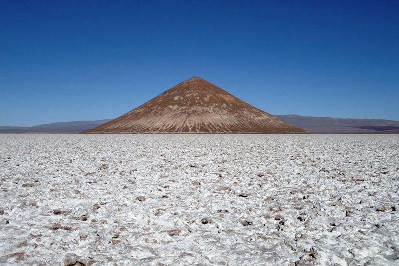
See. The Boszhira tract is located in the western part of the Ustyurt plateau. Kazakhstan. Can you see that the hills behind the Volkswagen are a wall formed by a bucket wheel excavator? 
Another Ustyurt plateau. Clickable. There is a group of cars in the middle of the picture. As far as the eye can see, the top layer of soil 100 meters thick has been removed. If you splash water here with a layer of 15 meters, you get an analogue of the Sea of \u200b\u200bAzov.
]]>
 ]]>
]]>
Sea of Azov. Flooded old quarry. The bottom is as flat as a table on which bucket-wheel excavators rolled. The maximum depth is 15 meters. 
The edge of the Karakum desert. Area 350,000 km². Clickable. The impression that some kind of planetary ripper worked on the planet.
]]>
 ]]>
]]>
In reality, a quarry. For the population of Yangikala Canyon. Turkmenistan. 
In reality, a quarry. For the population of the Tuzbair Plateau. Kazakhstan 
USA, Monument Valley. Clickable. Previously, the area of \u200b\u200bthis territory was as high as the top of the stub straight ahead. A layer several hundred meters high has been dug.
]]>
 ]]>
]]>
USA, Monument Valley. It's the same here 
Namibia. The desert is the bottom of a quarry 
Egypt. The top layer is removed along with the soil. They also burned it with a nuclear one. 
Most of Australia is hidden clean. There is no soil, all red desert. 
Australia. 
Nigeria. Desert. 
The conclusion is this for the deserts: they are completely anthropogenic. Appeared as a result of a long and barbaric metallurgical activity. And even more than that. Feel free to replace words in your vocabulary canyon, gorge, rock, ravine, plateau, mountain lake, just a lake- for words quarry, mine And flooded quarry, flooded mine.
On old foreign maps of the 16th and 17th centuries, where the territory of Ukraine, Russia and other former republics is often marked as Tartaria, the rivers flow more or less straight, turning smoothly. Modern rivers in this area meander strongly, sometimes turning 180 degrees. Here, for example, is a screenshot of the Tobol River in Siberia: 
One bank of such rivers is often higher than the other, and this is explained by the strength of Coreolis. I propose not to touch Coreolis and take a look at the following short video of the ERSHRD 5000 bucket wheel excavator and 2 photos of a river in Russia. Sorry for the mat in the video, but it is very visual.
And now a photo of the river in the Voronezh region. The place is called "Krivoborye". The river has never flowed through this loop before. It flowed here when the height of the landscape changed after the removal of soil by a bucket wheel excavator. 
Krivoborye from a different angle. On an island in the middle, overgrown with bushes, stood a rotary excavator. 
And what does official science tell us about this career? I quote:
The cliff "Krivoborye" is a huge ravine, a geological section, which is valuable for studying the geological past of the Voronezh region. According to the peculiarities of the soil structure and organic remains, geologists restore natural events that took place here several millennia ago.
The name "Krivoborye" was given in honor of the shape of the forest, which is located on one of its cliffs. This is a pine forest that is home to many large wild animals. Currently, "Krivoborye" is considered a national natural monument. On its territory, any activity is prohibited, except for sightseeing and educational activities. Students of geological and geographical faculties often come to this place to do research.
While all the geologists of the planet are unsuccessfully restoring what natural events took place in Krivoborye several millennia ago, I will do it for them - a bucket wheel excavator 200-300 years ago, judging by the unshaken slope. And this situation is typical for the whole planet. Often in a conversation you can hear accusations of cospirology. They say that it is impossible to hide anything from society. And there is some truth in this. Why hide when everything is in plain sight and no one sees?
Or here's another chutzpah. Obviously, a rotary excavator worked on limestone in Switzerland. But people are being told:
Creux-du-Van, a giant horseshoe-shaped rocky depression 1400 meters wide and about 200 meters high, a natural amphitheater formed as a result of rock erosion in the Jura mountain range in the canton of Neuchâtel.
Go ahead.
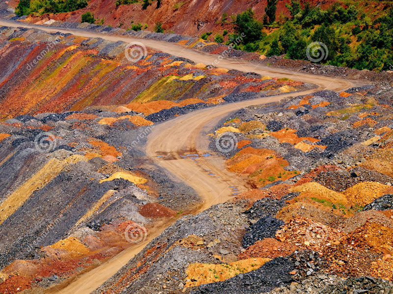
We put ourselves in the place of the one who guts the planet and move on to the next metallurgical stage. A rock with a certain content of the desired element was mined. What to do with her next? Before it can be sent for smelting or extraction of the desired element in any other way, the ore must be enriched in order to increase the percentage of content. For this, it is sent to GOKs - mining and processing plants. The concentrate is separated there, and the empty waste rock is taken to a dump or to a waste heap. You logically ask me, where are the deposits of waste rock with such gigantic volumes of ore mining? And I have to show you. Replace words in your vocabulary hill, volcano, hill into words dump and waste heap and everything will fall into place in your head. But it's better to see it once :)
These are waste heaps with waste rock from the Donbass. Their height sometimes reaches 200-300 meters. Chemical reactions often take place inside them, they burn and sometimes cry out when excess pressure builds up inside. 
And further 
And this is just a waste heap of Vesuvius in Italy with a height of 1281 meters. But it was called a volcano because it burns and exploded once. And they called it that so you wouldn't guess :) 
Shall we take a look at his caldera? If it's a volcano, then the walls of the caldera must be melted down by liquid lava. And if the waste heap, then the walls will be layered and will consist of crumbly rock, which can be dug with a shovel. We look carefully, gynecologists get together, do not think about work :) And what do we see? Terrikon... 
And this is a waste heap - the Klyuchevsky hill. Lit. 4850 meters. 
And this is the Santa Anna slag heap in El Salvador 
And this is the exploded top of the slag heap of Popocatepetl in Mexico. Height 5426 meters. 
Terrikon Maly Semyachik, Kamchatka Territory
From Wikipedia:
It is a short ridge with a length of about 3 km along the top, consisting of three merged cones - the ancient northern one, which is the highest (1560 m)
Tolbachik
From Wikipedia:
Volcanic massif in Kamchatka, in the southwestern part of the Klyuchevskaya group of volcanoes. Height - 3682 meters, the structure includes Ostry Tolbachik (3682 m) and Plosky Tolbachik merged with it (active, height - 3140 m). More than 120 cinder cones are located on the slopes of Plosky Tolbachik and in the adjacent Tolbachinsky Dol..
Shlakov, Karl! 
Haven't saved 4 paychecks yet to visit the slopes of the Fujiyama slag heap in Japan? Hurry, it's worth it :) 
We figured out the terikkons. Now let's move on to the dumps, which do not have a pronounced conical shape. Here the rule is, if loose and you can dig with a shovel, then most likely an oval of waste rock, which our ancestors piled on in a hurry to live.
For example, a chic geological park in China Zhangye Danxia. Colored mountains, beauty. Under state protection, of course. Tourists are driven exclusively along paved paths so that, God forbid, tourists do not fall into this toxic waste hen. 
Dump - Mount Schmidtikh, Norilsk 
Or, for example, you are walking along the valley of the Sugran River, in the Pamirs. Heaps of some kind of earth are piled around, nothing grows. And these are dumps. 
The mountains of Pyatigorsk are very similar to waste heaps 
The Philippines is one of the most desirable places to visit on the planet, and if you don't know much about the Philippines, then you should definitely listen to the world-famous island of Bohol. It became famous thanks to the "chocolate hills", which stretched over an area of about 50 square kilometers, in the amount of 1268 regular cone-shaped hills up to 100 meters high. 
In general, you understand the principle. We saw a hill near the house - take a closer look, think about it. Most likely it will be man-made.
And there are no natural caves on Earth. I reviewed a bunch of videos, all the caves are mountain underground tunnels of varying degrees of antiquity, often multi-tiered. Yes, many collapsed, began to look chaotic, but this did not stop them from being artificial.
The conclusions of this story can be drawn as follows:
1. Production volumes are outrageous. It is obvious that on Earth it is consumed well if 5% of the extracted. The earth looks like someone's giant quarry. Perhaps humanity simply serves this quarry.
2. People come and go, states appear and collapse, nations are formed, clash foreheads and disappear. One thing doesn't change: - ]]> God's millstones grind slowly but surely ]]>
The end point of our route, apparently the same as in the picture below. But even so, God's millstones will most likely not stop, so we humans will kindly design and build self-replicating robots by the time they take our place. They will not depend on the composition of the atmosphere, and we will go down in history. By the way, now you know what the "volcanoes" on Mars are :) 
But the logic of the process suggests that those who profit from this will not be very upset by our departure from the stage. Apparently, he is not here, he does not live here. I would like to know who this person is. As we all know, between the Lord (master), whose name cannot be named and must be written through a dash like G-d, and we are intermediaries - God's chosen ones. They would have to ask. Ordinary Jews hardly even knew what I showed in this post. But seniors know for sure. Start asking. We need a dialogue on this. In general, Judaism and religions derived from it, in the light of the revealed facts, seem to be a planetary management system - a quarry for a percentage. From time to time, when employees get into the topic and start to rebel, it is necessary to arrange a restart of the system by organizing wars and a generation gap. And since we got the idea what's what, it will probably start soon :) But what to be, it cannot be avoided. Power is in the truth. And the truth is that a society that lives in a closed system, continuously reproducing and determined to consume more tomorrow than yesterday - is doomed as soon as it reaches the ceiling on the amount of available energy or territory. It is possible to develop and multiply infinitely only in the infinite Universe. If we do not break out of the Earth quarry, we are doomed.
But on the other hand, if they wanted to hide it, then Sergey Brin would never have made a public service Google Maps, Google Images, and just Google. And no one would ever collect material on this topic in a heap in one place. So, not everything is so simple.
And for a snack, I want to show a couple of videos on the topic:
the last 40 seconds of the video are especially relevant
And the second one:
Bye then! Look for those who know the answers to questions and feel free to ask.
For example, the first half-joking question: how many rockets fly into orbit per year and what do they carry besides satellites? :) For example, a gram of Rhodium costs $230. A gram of Osmium-187 is $200,000, and a gram of California-252 costs $6,500,000. With the cost of putting 1 kg into orbit at $ 3,000, it is quite cost-effective to drag rare elements and isotopes there. Dirt stays here, clean product to the owner :)
]]> ]]>
Original taken from sibved in Kamchatka. Earth's ancient quarries?
The theme of ancient quarries does not leave many minds of those who are interested and seekers of parts of the truth. Among them is the author of these pages. It is already difficult to turn a blind eye to those signs and facts that say that at some time in the past our planet was almost a continuous quarry. Yes, it is shocking and shocking especially to those who read about such a version for the first time. Since the publication of the first articles on this topic here, there has not been enough serious criticism, there have been no comments from those geologists who occasionally looked through this journal. Either they silently twist their finger at the temple, or there is nothing to argue with. Let's see how readers react to the next part, according to skeptics: supposedly pseudo-science fiction ...
Many alternatives, researchers delve into our history, find inconsistencies, contradictions, chronological shifts, etc. But maybe it's all so petty compared to how they deceive us (or they simply keep silent about our real past and present, including the geological one). No, I do not want to say that the work of colleagues in the shop is petty and not important. This is all very important, it all adds clarity (and sometimes, on the contrary, additional questions) to the picture. I wanted to talk about scale. Perhaps not only the past, but also our reality, reality, the reasons for our existence (and not real life) on Earth are so monstrous in their simplicity and fantastic nature of the picture that it is easier for humanity to live as it is, and not to build a bright future ... This is what I mean that the theme of ancient giant quarries opens the question: who were we here in those eras and who are we here now? How much has changed since then? We are played, manipulated, pushed into wars. And if not wars, then just turmoil and chaos. This continues from century to century. With epochs of rise. And it is not known what lies ahead for today's stable territories and countries of the world. Maybe this is a limitation of technological development, so that we do not draw more than we should from the resources of the Earth? We kind of have to live at a certain level of development and awareness. Of course, there is an opinion that all the resources of the planet are renewable: hydrocarbons, water and metals. But exponents or curves of growth and consumption should not be equal, the second should be lower by all criteria. Probably, the rulers of the planet or their masters think so.
Here is such a pessimistic lyrical introduction with an element of terry conspiracy theories. And I will start this article with this comment:

This is in Kamchatka. The first thing Pauzhetka is known for is the Pauzhetskaya GeoPP:
Geothermal station powered by hot water.

geothermal springs. I wonder if anyone measured the background radiation near the ground? The commentator above could not have written misinformation ...
Geothermal springs and streams
I did not find any data that there are deposits of uranium or other radioactive elements in Kamchatka. Here is a screenshot from a book about the data of the medicinal lake Utinoe of the Parutino resort in Kamchatka:

Most likely, there are some foci of radionuclide releases, but not with boiling water, this happened to a person ...
The surroundings of the village of Pauzhetka are also interesting with such remnants:
Whether these are granites or volcanic tuffs is unknown. Most likely the second
I looked in Google maps around the village of Pauzhetka:

How did the slope of the volcano develop on Easter Island? Link on the map

View from the north. Of course, it looks like a giant landslide or the destruction of the slope of the loose rocks of the volcano by a melting glacier at the top. The formation of a circus, as geologists say
Ilyinsky volcano in winter. It's probably a landslide. Either it's an old photo from when the landslide was just starting, or it's a different volcano.
The cone of the volcano has no solid igneous rock.

Ilyinsky volcano in the background.

To the south there are such circuses on another mountain. Or is it something else?
Near Lake Kurilskoe. limestone mountains


Lake Kuril
Also near Lake Kurilskoye. Red soils.
This is what the neighboring hills look like.

A lake in the very south of Kamchatka. The ring shape of the hills surrounding the lake is traced. Approximately as in structure Conder. That, then Konder - these are dumps from the extraction of platinum (it is possible that it is underground) - for me there is no longer much doubt. There is 100% proof that these are dumps!
Moving north:

Crater Ksudach. Diameter - 7.5 km. What kind of volcano was this? Or is it a worked out cone of a volcano? Structure Conder almost one to one.
Inside view
Ksudach, oz. Stuebel

Inside the crater is smaller, a volcano, but the outer crater is just huge
The official version is also not ruled out that the dome of this giant volcano collapsed like the Santorin volcano in the Aegean Sea. But according to this logic, it turns out that all huge volcanic cones are hollow inside?
Volcanoes, hills in Kamchatka are different.

Volcano Kronotsky with the lake of the same name. If you do not understand the scale of this picture, then it will completely pass for a flooded quarry and a waste heap nearby.
Where is his vent, crater? It looks like a giant slag heap! And a quarry nearby - a lake
Maybe the version makes sense that many volcanoes are heaps-heaps that start to burn inside and erupt into the atmosphere ashes? Sometimes the molten rock comes out for a short time in the form of lava, thus the hill is practically indistinguishable from a volcano
This one did not catch fire, did not form a crater?
In theory, there should be at least a small, but a crater on top, like here. Karymskaya Sopka - also in Kamchatka
In some sources it is called Kronotskaya Sopka

Or did the crater crumble, erode, leaving a sharp peak?
View from the lake
Another pointed hill, which geology calls a volcano, is the Koryakskaya hill. This is the largest and highest hill in Kamchatka:

From left to right: Koryakskaya Sopka (3456 m), Avachinsky Sopka (2751 m) and Kozelsky (2189 m) volcanoes.
There is no crater on the hill like on volcanoes. And it is not clear how ash and lava were ejected without a crater? If it's a volcano, how could it grow into such a mountain?
Pay attention to the map, it shows the remnants, icons from two triangles of different sizes, with which topographers mark all such objects.
One such remnant is visible in this photograph. Maybe they are igneous, effusive, or maybe ...
Okay, let's say that if these are giant workings on the planet Pandora in the Avatar movie genre, then what could be mined here? Here's what, see:
Clickable
Clickable. There are even more deposits here, taking into account the unallocated fund. Kamchatka is a storehouse of polymetals and other minerals. But, probably, first of all, those who developed it were interested in gold, platinum, copper, nickel.
Ask a question why there are so many volcanoes in Kamchatka? Why are there no hills, volcanoes in the mountainous regions of the Alps, the Caucasus, Tibet, Altai? Geotectonic folding, earthquakes mean that there must be a release of underground power in the form of lava, gases, etc. And this is not. Magma close to the surface? Who installed it and how?
Yes, I still think this version is too fantastic. The scale is huge. What and how did they do it? Although, probably, there are already a lot of parodies of this among our equipment and technologies.
I am not saying that all volcanoes in Kamchatka are not volcanoes. Volcanic activity in the classical version of geology is not ruled out. Moreover, according to the news, it is often reported that the volcano Klyuchevskaya Sopka, Tolbachik, Sheveluch began to erupt.
Eruption of Plosky Tolbachik
Let's move to the Sea of Okhotsk:

Can you see the chains of underwater hills? Do you think that this is not what Google maps show? Maybe these are underwater volcanoes? But why do they go in a chain and at an equal distance from each other? But I think everything is right. Because one hill comes to the surface:
Iona Island. Link on the map
I also recommend looking at the Marshall Islands (near Micronesia) in Google maps - these are entirely calcareous underwater hills. But this is not the continental crust, it is not there in the Pacific Ocean. Who raked the lime into the giant underwater hills? Or how they were formed by geology?
How they pointwise rose from the bottom of the ocean - I do not understand. All flat, without volcanoes and mountains, only a few meters rise above the water. Allegedly, these are atolls - coral islands. But corals grow in shallow water, not kilometers deep. How did a coral mass grow an island from the bottom of the ocean? Stick around an underwater hill - maybe. Apparently, on this basis, scientists argue.
But I was already distracted and I was carried away far from Kamchatka ... Therefore, I finish.
To support this, dressing up in the language of some, pseudoscientific fantasy version, here are links to past articles:
Who built Vesuvius
Artificial volcanoes and deserts of the Earth
In conclusion, I will add that based on the myths and traditions of different peoples, statues, drawings, mosaics, mention the Gods - I had a certain conclusion about whose it is. But a regular reader of this can already guess for himself ...
Article by A.Yu. Kushelev is another confirmation that most of the objects of disputed (natural or man-made) origin are a by-product of the mining industry, a civilization unknown to us. The nature of their origin is akin to waste heaps near mines, and dumps at gold mining sites. It is here that the answers to the questions of skeptics who study, for example, the Kolyma megaliths, or Mountain Shoria, are hidden: - "Where are the traces of economic activity, tools, utensils, other household items that necessarily accompany places of long-term human residence"? "Where are the necessary door and window openings"? "Where are the stairs"? etc.
The answer, as always, is simple.
These are heaps in the Donbass. There are no windows or doors. There is nothing familiar, characteristic of the traces of human activity, but no one claims that these are "whims of nature"?
Nanoworld Laboratory
When reality reveals secrets
go into the shadows and fade miracles ...
Dmitrovsky Val through the eyes of aliens from Easter Island
(material for the newspaper "Dmitrovskiye Izvestiya")

What can connect Dmitrovsky Val with Easter Island?

At first glance, nothing. In Dmitrov there is a defensive rampart, on the island there is a volcano. The shaft was poured by people with shovels, the volcano is a natural formation. But imagine for a moment that you are Sherlock Holmes, who is entrusted with investigating a crime unprecedented by human standards. You have been approached by a citizen who claims that millions of tons of gold have been stolen here and there! If he turned to the police, he would be sent to a psychiatric hospital, but Sherlock Holmes solves incredible riddles not for the first time, so he is not in a hurry to call the psychiatric hospital, but listens to an incredible story...
Eyewitness account. I walked along Dmitrovsky Val and admired the surroundings.

Suddenly I noticed that the shaft was not round, but sharpened along the course of the Yakhroma River. It turned out that this shape of the shaft is typical ...

And when I got to the pointed end, i.e. down the river, he found that the shaft was washed out by water flowing over the edge.

Dmitrovsky Val. Reconstruction by A.M. Vasnetsov
How so? If there was water inside, then our ancestors could not build houses under water? It turns out that the rampart existed even before the foundation of the city and by the beginning of development it was already washed away by the Yakhroma River, and the water had already receded, i.e. inside the shaft it became dry and it became possible to build houses ... Then where did the Dmitrovsky shaft come from?
I decided to measure its height and found that in different parts it differs by more than twice! And this means that the shaft could not be poured as a defensive structure. After all, pouring extra 7-8 meters means doing 70-80% of the extra work. People would not do 5 times more than they need to. By the way, the mass of the Dmitrovsky shaft turned out to be almost a million tons! It's easy to calculate. The length of the shaft is 960 meters, the maximum height is 14 meters, and the width reaches 60 meters. The density of the soil is about 2 tons per cubic meter. A task for middle school students. Archaeologists and historians understand that it was impossible to quickly build a shaft, because. there were few people, and the shovels were wooden. Therefore, they decided that the shaft was poured gradually, which is reflected in the reconstruction, where its height is commensurate with the height of a person. But we already know that the rampart was completely formed and even eroded even before the construction began, i.e. it could not be poured after the founding of Dmitrov.
Curiously, other (serpentine) shafts have the same parameters (pay attention to the size and shape of the gaps), i.e. up to 15 meters in height, up to 60 meters in width, and their total length exceeds ... 2000 km! This means that their mass is more than a billion tons! Even the entire population of the globe 2000 years ago would not have been able to build the Zmiev ramparts, which in all respects include the Dmitrovsky rampart.
The excavations of the Serpentine Walls showed that there is nothing in them, except for waste rock. Wooden fortifications are extremely rare. It seems that in these places the already finished shaft was adapted to new (defensive) tasks. But the steep bank of the river was also adapted to defensive tasks. This does not mean that the river was built by people for defensive purposes? :) By the way, many shafts stretch along the banks of the rivers.
Dmitrovsky Hill. Photo by Nikolai Podshibyakin. Reconstruction by Alexander Kushelev
There is also a reservoir inside the Dmitrovsky Val. I decided to find out the composition of this water and passed a sample for mass spectral analysis.
In your water, the concentration of a rare and scattered precious metal (gallium) is 1000 times higher than the concentration in sea water, the specialist who conducted the analysis told me.
Wow... It means that in this place a precious metal comes out of the bowels of the Earth, which cannot evaporate together with water and gradually accumulates. How much of it could have accumulated in the zone of the Dmitrovsky shaft? If its content was the same as the content of platinum in the Nizhniy Tagil deposit, i.e. 800 grams per ton of rock, in the rock that forms the Dmitrovsky shaft could be 10 thousand tons of gallium.

Exploring the zones marked with numbers and letters, I came to the conclusion that the Dmitrovsky shaft was poured with the help of a giant mechanism.
I noticed that the height difference on the inside of the shaft is several meters less than on the outside, i.e. it seems that the rampart surrounds a hill washed out by the river. Then its shape elongated along the river becomes clear, resembling a cut chicken egg in projection. According to my estimate, the mass of the hill reached 4 million tons. This means that for the first time someone could mine 40,000 tons of gallium here, and the second time, i.e. when they poured a shaft around the eroded hill, they could extract another 10,000 tons of gallium. 50,000 tons of gallium at the prices I found on the internet cost the same as half a million tons of gold! Someone took away from here a thousand (or several thousand) times more than the strategic gold reserves of Russia!

Further research revealed a connection between the protrusion of the rampart and a small spring, where, according to my estimate, an additional 10 tons of gallium were mined.


Motnage by Alexander Kushelev. The image of the "flying saucer" is taken from the Larousse encyclopedia
To do this, the "flying saucer" after the main production had to return from the launch pad and fill up the protrusion of the shaft. "Krokhobory" - thought Dr. Watson ...
Well, it’s clear with Dmitrovsky Val, but what does Easter Island have to do with it? There is no shaft...
There is no shaft there, but compared to what happened on Easter Island, the Dmitrovsky shaft is just a prank. And it was like that. I am sitting at home, reading AiF. And there Ernst Muldashev tells how he went to Easter Island.

Geometric expertise by Alexander Kushelev
It turns out that so much has been cut off from this Rano-Raraku volcano that it was possible to make not 1000, but a million idols of 10 tons each! It's flooding, I thought. Need to check. I go to the Internet in Google Maps and see:

Volcano Rano Raraku, similar to a round cake, from which a piece is carefully cut off. The piece is about 800 meters long and over 100 meters high. This is seven times higher than the Dmitrovsky shaft ... In short, someone cut off 10 million tons from the volcano. This is more than the mass of the entire population of Russia :)
Physical and geometric expertise of Alexander Kushelev
Why would someone need a million 10-ton idols? To play soldiers? And what, they carry out military maneuvers, shoot at wooden (and not only!) targets. Why not shoot at 10-ton (and there are 300-ton ones on Easter Island!) soldiers?

Illustration from Thor Heyerdahl's book
The purpose of the maneuvers is known - to maintain shape in case of an attack. It remains to understand what they fought for? And I decided to look at Easter Island from the height of the satellite, i.e. through the eyes of aliens...

Who poured three burial mounds on Easter Island?

They are so huge that people thought they were volcanic domes...
But Sherlock Holmes conducts his own investigation and makes sure that the lighter material of the "mounds" does not fall below the surface of the slope. And this means that they were poured from above ... Later it turns out that there are a dozen more mounds on Easter Island, and the total mass of the megalithic complex exceeds 60 million tons. This is more than the mass of the Rano Raraku volcano ... To create such a handful of people is like building a tank for ants. In my estimation, the aliens mined several million tons of precious metals on Easter Island. This can be compared with mining in Egypt. There, other aliens heated the deposits of nummulites with dielectric reflectors shaped like pyramids. Tens of millions more tons of precious metals have been mined from the Dead Sea. Several tons of precious metals per day were mined in Baalbek, evaporating the largest river of ancient Lebanon, the Leont. But most of all could be extracted from the Mariana Trench. According to my estimates, only one cubic kilometer of gold could be extracted from sea water there. Do you need a cubic kilometer of gold? ;)
The aliens are taking millions of tons and even cubic kilometers of precious metals out from under our noses... Is it really that bad?
Why not? As a well-known chess player said, one game of chess lost is worth ten won... If we learn how to mine precious metals as efficiently as aliens, then we will be able to mine millions of times more efficiently on our planet, and "take revenge" on other planets. ..
And what, the aliens will allow us to take revenge?
Let's apply the famous deduction method. Those aliens who mined precious metals and poured the Dmitrovsky shaft have long created a "self-assembled tablecloth" and they have ceased to be interested in mines. And the natives, on whose planets we can take revenge, do not yet know that there are "flying saucers" with aliens :)
Let's say. And who will tell us about the technology of mining precious metals by aliens?
Well, listen to the third story... It was the summer of 7515 from the Creation of the World or 2007 according to the new style. I was returning with mushrooms from the forest. Before reaching a few steps to my dacha, I noticed a circle of trampled grass. The blades of grass were stacked very neatly, not broken, but bent at the knees... Examination under a microscope showed that there were burns on the knees, as with strong irradiation. The blades of grass were twisted into spirals, as if charged particles were flying in a strong magnetic field under the influence of an electric field ... Then I decided to check if there were any precious metals in this place? Mass spectral analysis showed that everything in the soil was normal. In plants too. However, analysis of spring water showed that the concentration of gallium in it is approximately 700 times higher than in sea water. Water brings gallium to the surface, but it is practically absent in irradiated plants and soil. Where does he go? It was then that I imagined how charged gallium ions fly in spirals ... And who charged them? And then I remembered about ionizing radiation. Maybe it left burns on the knees of plants? But why did the radiation ionize only gallium? I decided to figure it out and found out that there is a characteristic radiation that is absorbed only by certain chemical compounds or elements, for example, gallium ... This is how the technology of extracting precious metals became clear in the first approximation. At midnight, when the Sun does not interfere with photographing the Earth's surface with flares that have a special spectrum, the aliens find spots of increased concentration of precious metals. Then they irradiate these zones with characteristic radiation, ionizing only what they need. And you can extract ionized precious metals with an ordinary electric field. And we will be able to do this when we have cheap electricity. After all, the power of the characteristic X-ray radiation should be several megawatts, and in a couple of hours a ton of gallium can be pulled out of a small swamp ...
Well it is clear. And where will the money come from to create a new energy sector, a new extractive industry?
To begin with, you can organize an expedition to Easter Island, to prove to mankind that on the island, in addition to volcanoes, there are a dozen artificial hills, the mass of which approaches the mass of the Rano Raraku volcano. When it becomes obvious to many that the aliens have mined tens of megatons of precious metals there, then there will be people who also want to mine millions of tons of precious metals. In the meantime, there are such people, you can organize a museum right under the bulk hill, making a tunnel under it. After all, a volcano should have a vent through which lava rose from the ground, but a mounded hill does not have a vent. Each visitor of the museum "Under the alien roof" will be able to make sure that there is no vent, which means that it is under the "alien roof"...
If each museum visitor donates a dollar, then very soon tourists will be able to fly over Easter Island on flying bracelets of domestic production, like bird people from Easter Island;)
On Earth, there are many rock formations of bizarre natural origin. The arguments of geologists and scientists that nature is capable of this, because.
the process of obtaining what we see took more than one million years. But there are no detailed models, with diagrams, elementary calculations, in any textbook.And these opinions of official science can hardly even be called a hypothesis, let alone a theory. These are just versions. I'm not talking about all the fancy objects. But there are many such processes of natural forces that stand out from the category. In this article, we look at the next ones, and let everyone draw conclusions about what it is: natural or artificial.

This topic of my fellow countryman and colleague izofatov is more and more overgrown with facts, though not always direct, indirect, but still, with a larger volume of examples and reflections than geologists on these objects. I know that many think when they see articles like this. This is an appeal to them.
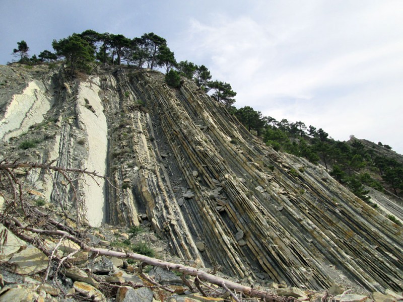
The first object we will consider is the Devil's tower, USA

Map Link
As you can see even from this photo, this is something of igneous origin, originally plastic, although everything around is from sedimentary rocks. Every year the rock is visited by thousands of tourists and climbers. Its unusualness - lures the human eye. This is how a person works - he reaches out for what he cannot explain.
Rock in Wyoming, USA. It is a monolith of volcanic origin with a height of 1556 m above sea level and a relative height of 386 m. The Devil's Tower was formed from a magmatic melt that rose from the depths of the Earth and froze in the form of elegant columns. The Devils Tower is estimated to be between 225 and 195 million years old. The host rocks are dark red sandstones, silts with shale layers.
Immediately the question is - how can this be an igneous rock, if the rock contains sandstones? And this is not even granite (recrystallized rock with sandstone), there is not a word about it. Let's remember this fact.

As they say - side view. In terms of structure, it is an igneous rock that cracked into hexagons during its cooling, when it came out of a round hole in the ground. Although faults of such forms are not observed. But that's what official geology says.
If you look closely, you can see that the foot of the massif is just a stone massif with cracks of a chaotic shape, above there are regular hexagonal-tubular formations, which again have a larger number of cracks at the top.

Another observation - at the foot, these tubes are bent, as if they initially came out at an angle to the surface, then they closed the circle and climbed vertically shoulder to shoulder. Or cracking at the foot for some reason went at an angle. Strange.


At the foot of the cliff there are volumes of kurumnik - these are collapsed segments.
Panorama kurumnika at the foot of the cliff

Do the hexagons themselves “climb” from erosion, or did they initially have a surface layer of a different structure in their structure? It's also unclear.

Some segments have an equally strange ribbed surface.

Segments with horizontal cracks


Why the segments have a more or less regular shape, and are at an angle below, as if, on the contrary, they were squeezed out from a height through the honeycombs. The mass first fell, turning into a shapeless substance, then rested on the surface, and began to spread to the sides, when the efforts of gravity or external influence became insufficient - the segments stood up vertically and everything ended abruptly, forming a flat top. I tried to explain what I see from the standpoint of the logic of the process and the forces that give rise to this formation.
Yes, it’s fantastic, it looks like the sci-fi movie “Oblivion”, where water was pumped out of the Earth, and in our case, taking the soil, processing it in something (izofatov calls them directly, in Vedic terms - vimanas) and throwing (squeezing out) on surface already unnecessary mass. Because of the heat treatment, it quickly petrified. And since the mass at the top of the rock has a large fracturing, I can assume that the temperature of the rock remains was much higher than the previous masses.
And this technology of dumping the processed rock includes all the remnants, pillars, walls, which, like the Devil's Tower, are not clear rocks (under-granites) - like the Krasnoyarsk pillars, for example, in composition from syenite.
What was extracted from these masses of soil or other rocks. Most likely, rare earth metals, which, for example, are on our planet, but they are few on other planets.
If we take into account all versions of the formation of this rock, then there is a version of impact origin from axsmyth, who claims that this rock outcrop occurred as a result of a breakdown of the earth's crust by a dense and very high-velocity asteroid. And in fact, there is a crater seven kilometers to the west:

Diameter 850 meters
Another selection of similar formations:

Unfortunately, I don't know where it is.

Ireland. Path of the Gods (Road of the Giants)


If this is natural, then why did such cracking occur only in such a local place? There is also a frozen rock on the side. But she's shapeless
Perhaps these examples include Nan Modol, Indonesia:


Also a table mountain
From the segments of which these incomprehensible masonry are built:

And also, Masleevsky pillars in the Krasnoyarsk Territory include:

I will not insist on the account of this version about the last examples, and it is quite possible that in nature there really is a process of rock cracking into hexagons during crystallization, and if vice versa, then these are quite rare examples. Much more often one comes across simply shapeless remnants in the form of rock overlays in the form of pancakes one on top of the other. So let's move on to the next example:
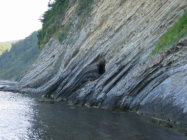
Stone remains of Demerdzhi. Crimea
Original taken from
Good afternoon dear readers.
I suggest you continue to rock the dilapidated building with a sign over the entrance - "the official history of mankind." Many readers in the comments to my last article - "An industrialized civilization has existed on Earth for tens of thousands of years", located here -
frequently asked questions:
1. What does the author smoke?
2. Can he sleep?
I answer:
1. In my free time I often smoke books and articles on a variety of topics.
2. Maybe. I'm sleeping right now :)
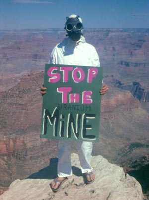
The title of the article shows that it will be about uranium mining in the United States, but not only. The material will be much wider. I will try to give you all the search queries that I used, so that you can independently not only check the information, but also personally participate in the discovery of new interesting facts. Very soon you will realize that the man in the photo above with the "Stop the uranium mine" poster protesting the opening of new uranium quarries in the Grand Canyon, without knowing it, is protesting like a bee against honey. In fact, he is protecting an ancient uranium mine from further development! Oxymoron:)
One of the rules that I use to search for traces of resource extraction by an industrial method in ancient times is this: if a certain resource was previously mined in one place and the entire volume was not exhausted, then other people, no matter how many years later, will return to this place and continue prey. I will illustrate this thesis with an example from the Crimea. There are two limestone quarries in the video. One is modern, and opposite it, across the road, is ancient. Judging by water and wind erosion, the ancient one is several thousand years old. Be sure to check it out for clarity. The video is short, only 30 seconds.
Following this rule, you can easily download maps of active modern deposits from the Internet in any country or region for any element of the periodic table of interest, as well as for any combination of elements, and then just visually compare. It's easy, educational, fun. Like a game quest. To search for such cards, use the search words:
Map of mineral resources of Russia
The map of the mineral resources of the region is such and such
Minerals map of Russia
Minerals map of the area such and such
map of copper ore reserves
map of uranium ore reserves
map of bauxite reserves
and so on. Then click show pictures.
By analogy, repeat the search in different languages.
Now I will show you the example of an ancient mine - the Grand Canyon in the USA: 
I found a US map showing high uranium areas by searching for uranium mining reserves Usa: 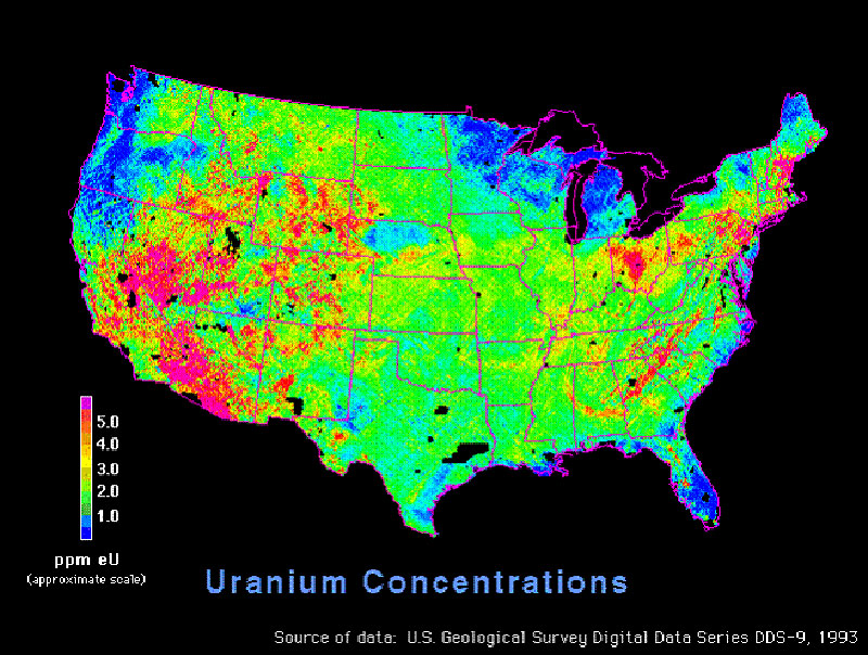
And the second card 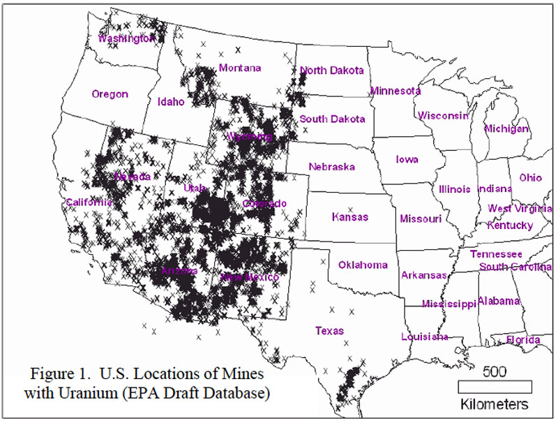
I then compared the top maps to the location of the Grand Canyon: 
The canyon fell into the zone of maximum uranium concentrations. Then I narrowed down the search criteria and began to read the material on demand Grand Canyon Uranium mining. And found some interesting stuff. I demonstrate some of them:
Article titled
Uranium mining near the Grand Canyon should be permanently banned
And a map with applications for uranium mining around the Grand Canyon from the article: 
And the second card 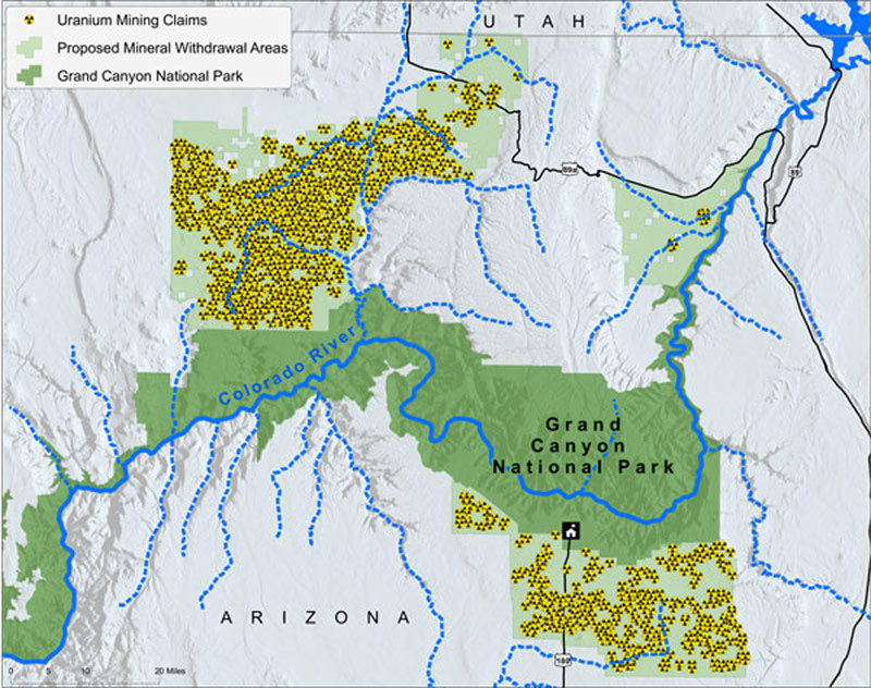
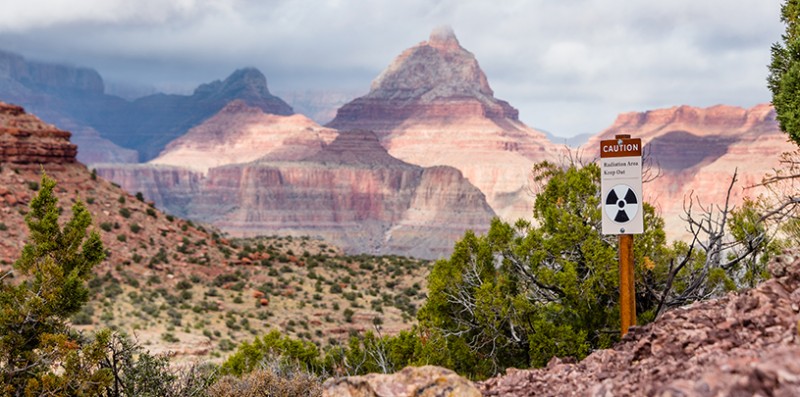
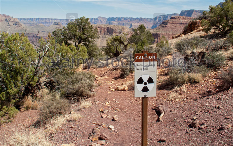
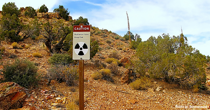
the map clearly shows that the undeveloped areas around the Grand Canyon are of great interest to uranium mining companies. Do you understand what I'm getting at? :) That is, earlier, they did not have time to fully develop all the uranium-containing rock in this area. They worked out only the volume, which later became the Grand Canyon. In the "Canyon" area there are a lot of decently "fading" places, as signs warn about:

Well, how? Is history starting to play with new colors for you? Someone long ago had a huge amount of uranium in their hands, which could be used both for energy and for nuclear war. Are you still interested in official stories about how past generations exchanged sable skins for hemp and sailed on oared wooden galleys and sailing gulls? They probably changed and swam, but studying this simple life is like studying the history of the Maori people in Australia now, while such transnational mining corporations as BHP Billiton, Rio Tinto, Glencore Xstrata and Alcoa are operating next to them .
Using the example above, you can now independently explore the terrain in your area. And thus, by cooperating, in contact with miners, workers in the mining and processing industry, who know those processes from the inside, you can complete this puzzle. Remember all:)
Now you need to imagine that you have a planet in front of you, on which you need to deploy a full-fledged mining and processing industry. You have a limited amount of equipment. The first thing you will start with is to increase its quantity. What is needed in the first place for this? Energy. Any manipulation of matter requires energy. And then steel. No machine or plant can be built without a wide range of different grades of steel. And to produce steel, you need iron ore, alloying additives - chromium, nickel, molybdenum, manganese, etc., coal and flux limestone.
Coal is generally needed for the process of reduction of any metal oxides. Oxygen atoms in the blast furnace are taken from the metal oxide as a result of a reduction chemical reaction and are added to the carbon contained in the coal. Limestone and dolomite are used as fluxes in the metallurgical processing of ores in order to form fusible slags for easier removal of impurities. " Their widespread use in ferrous metallurgy is due to the fact that a significant amount of basic oxides is required for fluxing the waste rock of ores and coke ash. In addition, most production processes are aimed at removing harmful impurities that can be completely or partially removed from the melt when working on basic slags. For the formation of the latter, significant additions of the main flux are necessary. The most important requirement for them is a low content of silica, alumina and harmful impurities (sulfur and phosphorus)". That is, without limestone - nowhere.
Here is the blast furnace loading scheme. Limestone - limestone, coal - coal, iron ore - iron ore: 
With coal, everything is clear from my last article - all the burning cone volcanoes are, most likely, coal heaps. Here, by analogy with the coal heaps of Donbass, you need to understand. They contain a decent amount of residues of coal dust and crumbs, and therefore such spoil heaps and volcanoes-heaps burn very actively. The color of the constituent rock in the Donbas waste heaps and volcanoes is the same. You can try to compare the location of volcanoes with a map of coal basins in different countries.
By the way, to the statement that volcanoes are burning heaps, a critical remark was received that heaps cannot have a layered structure inside, as in the photo:
Volcano-terrikon Nyamlagira: 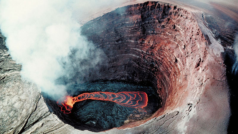
And they should have a uniform structure inside, like an anthill cake. I put forward a counterargument: cone heaps are poured using transport tapes, as in the photo:

A similar process can be observed in an hourglass. With this method of filling, layers of different colors of the rock will inevitably form and the layers will be parallel to the surface of the slopes of the waste heap. The photo below shows the result of emulating this process. It's called stratification. 
That is, volcanoes are waste heaps. Here is another very clear proof of this statement:
45 years ago in the Donetsk region there was an explosion of a waste heap, which contemporaries included in the list of man-made disasters in Ukraine. The article is called - "Looking around, I involuntarily recalled the painting "The Last Day of Pompeii"". Quote:
On June 10, 1966, at 23.00, a piece with a total volume of 33 thousand cubic meters broke off from the old waste heap of the Dimitrov mine of the Krasnoarmeyskugol trust in the city of Dimitrov (Donetsk region). Hot multi-ton boulders and a loose mass of red-hot rock slid onto a residential village, burying a dozen houses with people under them. After the displacement of rock masses from the cavity formed in the lateral part of the hundred-meter waste heap, as from the mouth of a volcano, hot ash, dust and steam were ejected, the temperature of which reached 3000 (!) degrees. The tragedy that happened was first written about only 30 years later ...
By the way, on the shores of seas and rivers, you can often see a conical mountain half-collapsed from the side of the water, consisting of layered sandstone. Perhaps this is an ancient compressed waste heap. Examples in the photo:
Now let's move on to the extraction of iron ore. I want to show you some interesting analogies. The last article already featured photos of China's geological park - Danxia: 
I will add the town of Purmamarca, Andes, Argentina 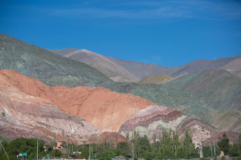
Hornocal Mountains, Argentina 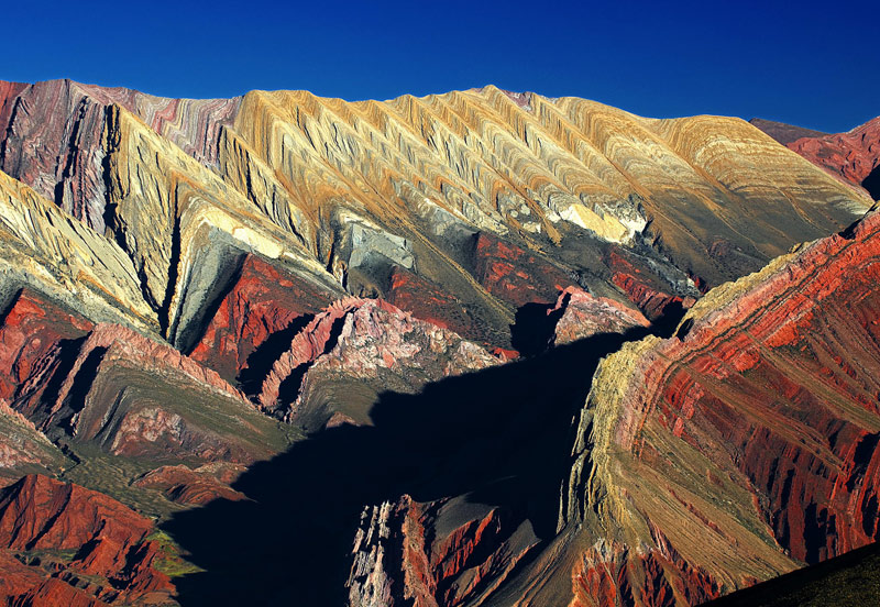
Mountains of Vinicunca, Peru 
Compare them to the following dumps:
Colorful depleted iron ore dumps 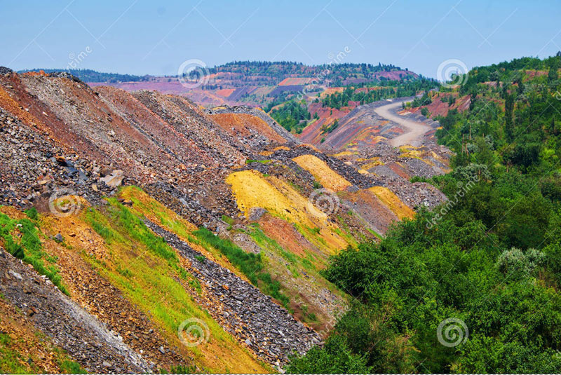
Iron ore 
Iron ore 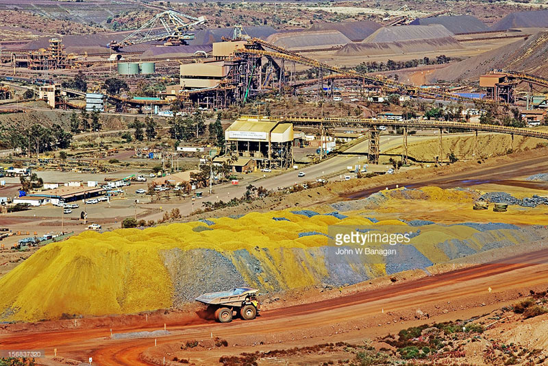
Let's return to the town of Purmamarca in Argentina. Let's look at a fragment of the Andes mountain range from the satellite coordinates: -23.654545, -65.653234. Raise the camera, take a screenshot of the area, ~ 150 km wide:
Click the picture to enlarge. 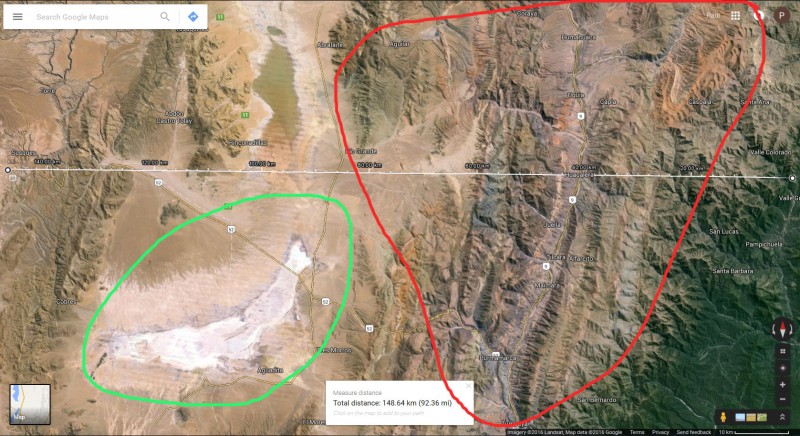
In the screenshot, I circled in red a small fragment of the Andes, with a diameter of 100 kilometers. These are colored dumps from mining and metallurgical activities, and it was naturally mined here, not only iron, but the entire periodic table. You can zoom in on the camera and take a look. And it is better to inspect all the Andes at once. A sure sign of dumps and waste heaps is the erosion of their slopes. It appears under the influence of precipitation. The slopes are covered with waterholes. If you see mountains whose slopes are covered with such waterholes, then these mountains are formed from loose materials. Hard rock fragments can even stick out of their tops, but don't let that bother you, as exothermic reactions often take place inside dumps and waste heaps and loose material can melt. It may even just sag. A prime example is sandstone. A hard rock formed from sand.
Photos of dumps with water holes: 
You should take a closer look at the hills and mountains with such erosion. The shape of the mountains does not really matter, it can be any, especially considering the repeated recycling of dumps. 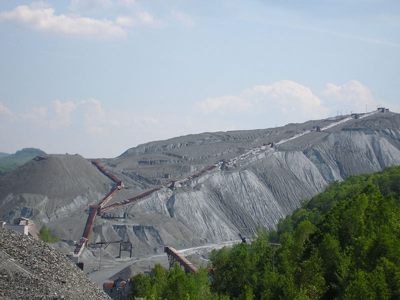
Layers of different colors in the dumps are formed in this way: 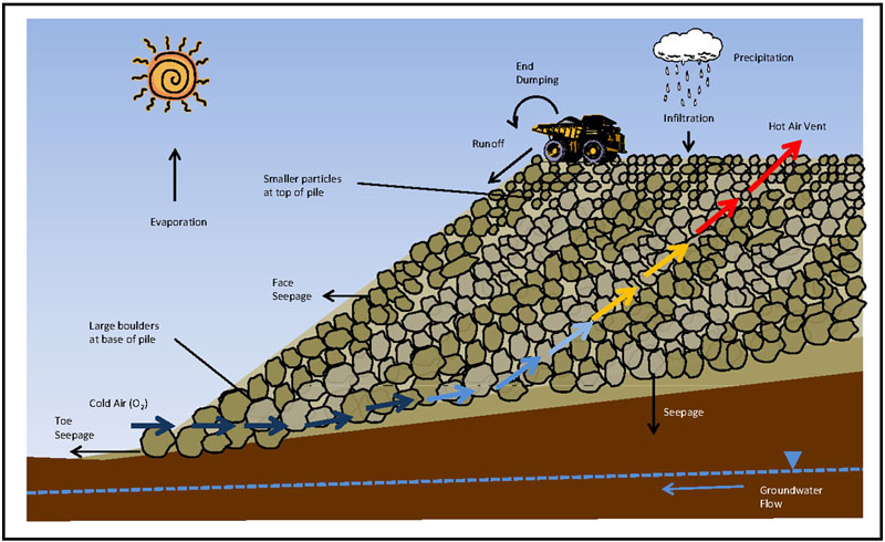

Notice the bottom of the salt lake in the satellite screenshot above. I circled it in green. It is called Salinas Grandes and is 45 km long. The distance from it to the ocean is 450 km: 
Here are pictures of the lake and surroundings 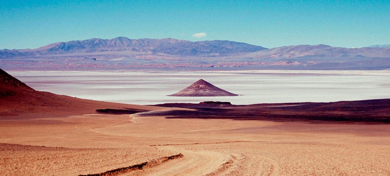


There are two things you need to know about this salt marsh and (and thousands like it on the planet):
1. It is being re-mined. Salt, potash, borax and soda are mined.
2. And the second thing that is directly related to these types of lakes is this:
Methods of chemical processing of ores can be divided into two main groups: acidic and alkaline. As a result of the dissolution of mineral raw materials, the elements of interest and their compounds pass into solution, from which they are then removed by thickening filters and vacuum filters. The brine remaining from the process is drained into sludge storage tanks.
The sludge accumulator is the main type of surface storage, which is constructed according to a single or multi-stage principle with the creation of a dam, banks, and also a sludge storage. In the sludge reservoirs, natural processes occur - the accumulation of atmospheric precipitation, the development of microorganisms, the occurrence of oxidative and other processes, i.e. self-healing takes place, however, due to the presence of a large amount of salts with a general lack of oxygen, the self-healing process takes tens and hundreds of years.
Google pictures by tags sludge accumulator, tailings or tailing pond.
I will show you photos of working sludge collectors. They accumulate tens of meters of liquid waste thickness.
Tailings pond at Stawell mine 
Tailings dam at Tanjianshan. To create a sludge reservoir, a dam is being built. Over time, on ancient dry sludge reservoirs, the dam can degrade and lose its shape. This will make it possible to pass off the object as a salt marsh. 
Tailings dam The Sierrita Copper Mine. Sludge dam at the Sierrita copper mine. 
Sludge accumulator - Belaruskali. Future mountains on the horizon and a dry salt lake. 
Alberta Tar Sands Tailings Pond 
Tailings Pond Ernest Henry Mine 
Highland Valley Copper EYNAKR sludge dam construction 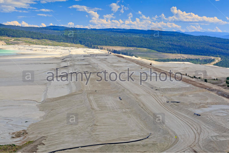
Here is a diagram of the sludge reservoir dam. Sludge -tailings is marked in gray: 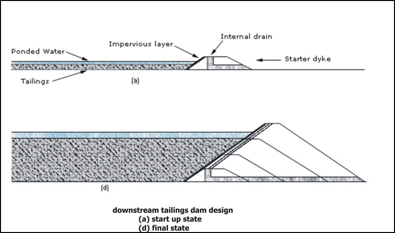
Sludge collector options 
Sometimes sludge reservoir dams break through. And then the sludge floods the settlements located below: 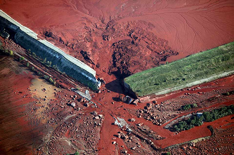
Consequences of the breakthrough in Hungary. This is sludge from the processing of bauxite. Aluminum mining 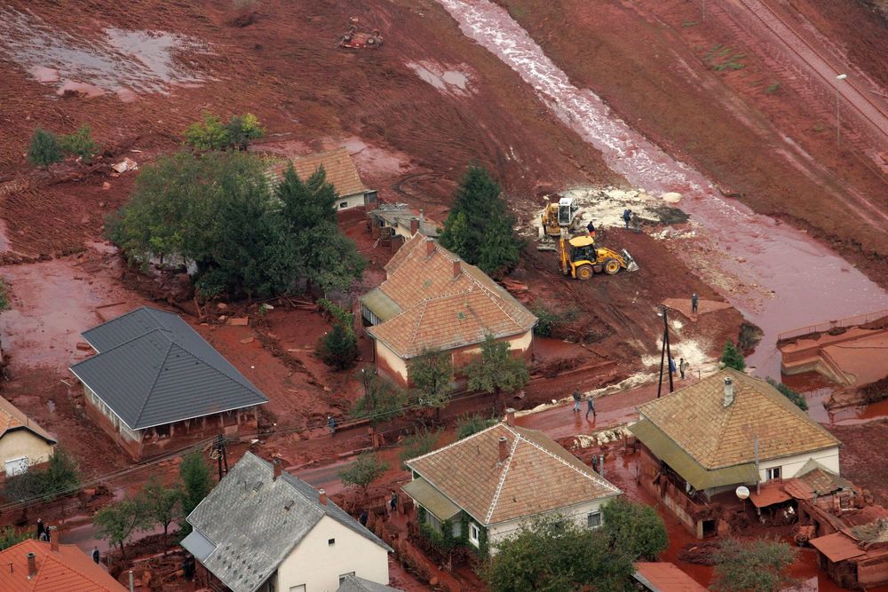
Consequences of a breakthrough in Brazil 
Most of the reservoirs, by the way, with earthen dams, are former quarries used as flooded sludge reservoirs. I am engaged in spearfishing, and dived in many of them in the Crimea. In the Partizansky reservoir, the Simferopol reservoir, the Happy reservoir. Everywhere one and the same picture was observed - underwater ledges, horizontal shelves of the bottom of a large area, for example, at 5-7 meters of depth, which, at a considerable distance from the coast, abruptly break off in a steep slope inland. The composition of the bottom is white lime pulp, fine lime chips. and often it is impossible to dive to the bottom, because the transparency at a depth of 7-12 meters drops sharply to zero due to the white lime emulsion, which, as if by level, is in a horizontal plane.
Here is a photo of the Schastlivensky reservoir in the Crimea. The hills in the background are loose. Dumps: 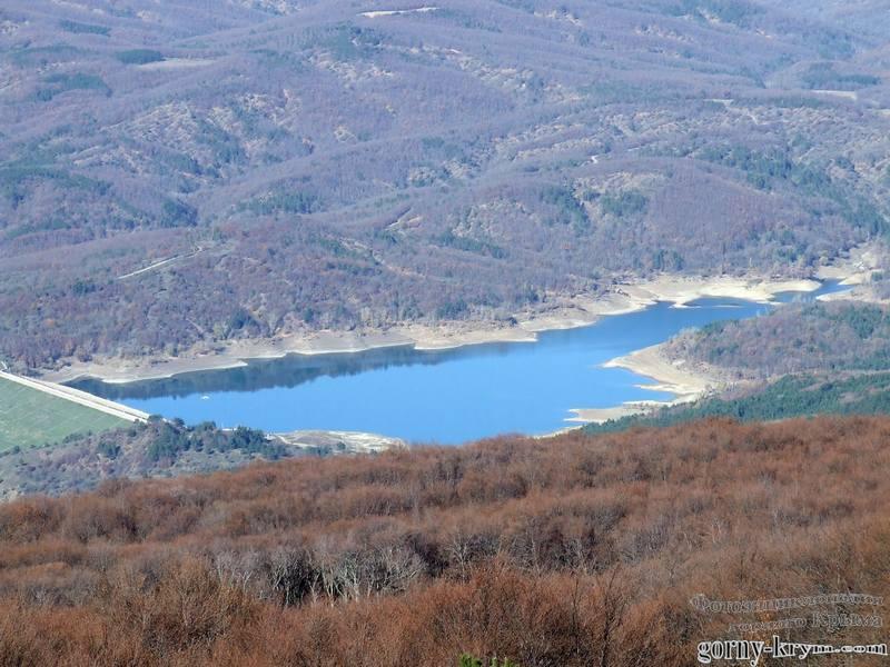
In support of this statement about reservoirs, I present an interesting piece of news. After Crimea returned to Russia, we switched to Russian standards. And Lake Gasfort near Sevastopol, where I also dived, quietly moved from the status of a reservoir to the status of a sludge reservoir. At the same time, Lake Gasfort remains a reserve source of water supply for Sevastopol. 
And even a small lake in Pirogovka near Bakhchisaray, 16 m deep, where I shot pike, turned out to be flooded with a sludge trap. At the bottom of fat white-gray silt. On one side, the water mirror is supported by an earthen dam. And on the horizon, either sawn limestone terraces, or dumps of lime chips. Virgin Crimea, the pearl of Russia :) Clickable: 
In modern metallurgy, the turnover has fallen, of course. There used to be scope. Dead Sea, Israel. Huge ancient sludge collector. Moreover, at first it was a quarry. And after the breed was chosen, they began to use it as a sludge accumulator. This is a logical and common practice: 
The current water level in the Dead Sea has fallen. I believe the backing dam is much higher than the level. Circled in red: 
Great Salt Lake. Great Salt Lake. USA. 117 km length: 
Great Salt Lake. The length of the backing dam is 17 km: 

Tuz Golu. Türkiye. 905 meters above sea level. 75 km length 
Nau Co Lake, Tibet. Height above sea level 4378 meters. Next to it are large-scale colored dumps. Clickable 
Bonneville Salt Flats, Utah
The Bonneville Desert, about 240 sq km, is known for the extraction of salt, the same table salt (90% of the total production in the USA), as well as other mineral salts, potassium, magnesium, lithium, soda 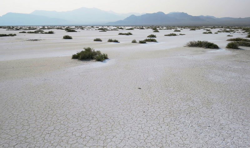
On the surface of dried sludge pits, people set speed records: 
In general, you understand the principle. If you are interested, run Google maps, look for white salt spots on the continents, zoom in, look for the remains of dams, there will be dumps with erosion on the slopes nearby. Look at the maps of mineral resources to see what is currently being mined in these areas, what explored minerals are, and the picture will begin to emerge. But it should also be noted that there is a reasonable version of the overflow of salt water by tidal water from the oceans inland, so salt lakes close to the coastline can form for this reason. Therefore, to be sure, you can start to analyze the salt lakes and deserts located high in the mountains. In Tibet, for example, there are 250 salt lakes.
Now we turn to the extraction of limestone, without which it is impossible to remove slag when smelting metal from ore. Above, I showed that a lot of metals were mined. So limestone is needed a lot. In the first article, I showed the scale of limestone mining in the Crimea. But then I thought that it was used mainly for construction. It turns out not. It was and is used as a flux, for the production of soda, quicklime. And as a means of neutralizing the pH of sludge pits. This reduces the level of environmental threat. In general, limestones are very widely used in metallurgy, food, pulp and paper, coke, glass and paint industries. We turn to photo materials on limestone:
These are the chalk waste heaps of Slavyansk. 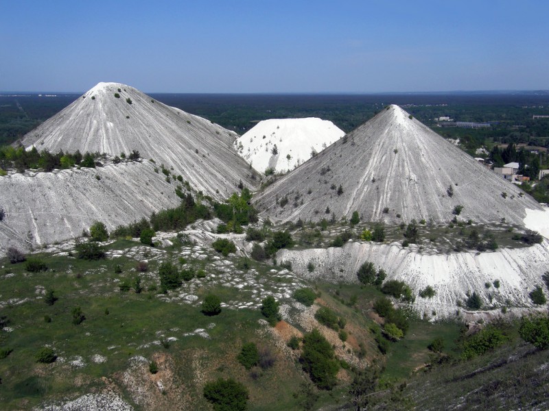
It can be seen that their local population is slowly tearing them down - chalk is useful both for whitewashing and for the soil as an additive. 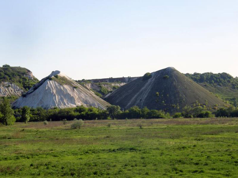

I will write an assumption about such an important aerospace metal as aluminum. It is mined from bauxite, the main mineral raw material for the aluminum industry. Looks like clay. Keyword to search - bauxite mining. Mining scheme: 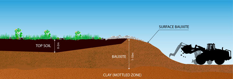
As can be seen from the diagram, the fertile soil goes to the dump. Then a layer of bauxite is removed from a large area. Photo of modern production:
Bauxita Paragominas, Brazil 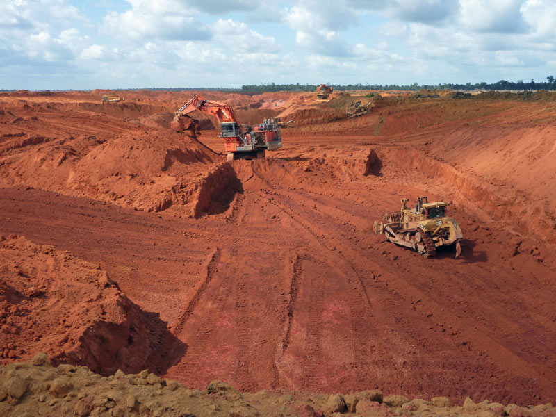
Bauxite mining 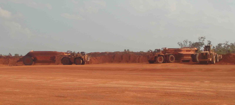
Brazil, bauxite mining 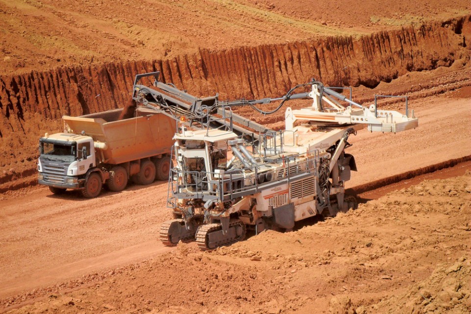
Alcoa bauxite mines 
Kuantan bauxite road red. Red bauxite road in Kuantan, Malaysia 
Rio Tinto's Bauxite Mine at Andoom, Australia 
Given the scale of the metallurgy of the past, shown by me above, the question arises - where did the soil go in a number of countries in Latin America, Africa, Australia and other countries? If vegetation is not disturbed for thousands of years, not even forests, but meadow and savannah, then a layer of humus will form. But we see such landscapes in these countries:
Africa 
Africa 
Australia 
Brazil 
Australia 
Australia 
Namibia 
Namibia 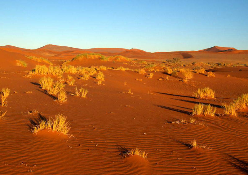
Namibia 
There is something to think about. In what year, according to legend, the king was presented with aluminum spoons, which were valued more than gold? :)
I'm rounding up on this. I hope you were interested and you will solve many more interesting riddles as a crossword puzzle using google maps in your free time.
Bye!
ps: I congratulate all girls and women on the upcoming day of the defender of matchy:) Happy March 8 to you! Happiness, love and keep your tail with a gun.